button to pause/resume
the scenario (Navigation mode).
button to pause/resume
the scenario (Navigation mode).Click GNSS node, and specify Advanced Real-time Signal Generation for Capability cell.
Keysight Signal Studio for GNSS will display the following Toolbar Functions and Parameters.
|
1. Capability |
2. General |
3.Scenario Information |
|
Constellation Control Table |
Multi-tone Interference Table
|
Coupling: Visible with the Capability selection of Advanced Real-time Signal Generation and active while playing a scenario.
Click the button to pause/resume
the scenario (Navigation mode).
EXG/MXG:
[:SOURce]:RADio:GNSS[:BBG]:SCENario:PAUSe
[:SOURce]:RADio:GNSS[:BBG]:SCENario:RESUme
Coupling: Visible with the Capability selection of Advanced Real-time Signal Generation and active while playing a scenario.
Click the button to restart
the scenario (Navigation mode).
If a Scenario Start Time Offset value is entered, the software restarts the scenario at the entered offset time value. The progress bar also restarts from the offset value.
EXG/MXG:
[:SOURce]:RADio:GNSS[:BBG]:SCENario:RESTart
Coupling: Visible with the Capability selection of Advanced Real-time Signal Generation.
Click this button
to reset the current satellite channel settings in the Satellite Settings tab:
|
Navigation mode |
When the signal is not playing, resets values according to the start record of the current scenario. When the signal is playing, resets , , , and columns to their default values. |
|
Static Test mode |
When the signal is not playing, resets values to default settings. After turning on, the software updates the column with values derived from the power calibration. |
Coupling: Visible with the Capability selection of Advanced Real-time Signal Generation, and active only when the signal is playing in Navigation mode.
Click the button to disable or enable the query from instrument for UTC display.
EXG/MXG:
[:SOURce]:RADio:GNSS[:BBG]:SCENario:UTC?
Coupling: Visible with the Capability selection of Advanced Real-time Signal Generation.
The Progress Bar shows the UTC time of the scenario playback when using User Scenario Files, shown as follows:

Choice: Advanced Real-time Signal Generation | Basic Single Satellite Waveform\Basic Multi-satellite Waveform
Default: Advanced Real-time Signal Generation
|
Selects a pre-generated single satellite waveform file and downloads it to the instrument for playback. |
|
| Basic Multi-Satellite Waveform | Selects a pre-generated multi-satellite waveform file and downloads it to the instrument for playback. |
|
Loads in a scenario file and generates a real-time GNSS signal, or provides continuous real-time scenario generation based on the Scenario Generator node settings. The Scenario Source selection determines whether to use a file or continuous real-time generation. |
Select the capability of GNSS signal simulation. Basic mode generates and downloads user defined single satellite waveform or multi-satellite waveform to instrument for playback. Advanced mode plays real-time navigation signal based on user selected scenario file or static signal based on satellite settings.
Choice: Navigation | Static Test
Default: Navigation
Select the simulation mode of GNSS signal.
|
Navigation |
Simulates a real-world GNSS signal that is generated in real-time with navigation data that changes during the simulation to reflect movement of the satellites over time. Within the Satellite Settings tab and while the signal is playing, you can deselect active satellites and change the relative power between satellites. |
|
Static Test |
Simulate a static GNSS signal where the satellite channels and settings are initialized by a scenario file, but do not change with time (as if the satellites were frozen in time). Within the tab, reconfigure the properties for each active satellite initialized by the scenario file, and manually activate and configure the properties for inactive satellites. |
EXG/MXG:
[:SOURce]:RADio:GNSS[:BBG]:SIMMode NAVigation|STATic
[:SOURce]:RADio:GNSS[:BBG]:SIMMode?
Choice: User Scenario File | Scenario Generator Settings
Default: User Scenario File
Coupling: Visible with Navigation as the Simulation Mode.
Select the type of scenario data source for playback.
|
User Scenario File |
An existing scenario file will be used for playback. Use the Scenario File cell to load the existing file. |
|
Scenario Generator Settings |
The software continuously generates scenario file data in real-time based on the settings in the Scenario Generator node. |
[:SOURce]:RADio:GNSS[:BBG]:SCENario:SOURce <USER | SGEN>
Choice: Local | Instrument
Default: Local
Coupling: While Navigation is the Simulation Mode, this property is visible when User Scenario File is the Scenario Source
Select the location of scenario file for playback. Local means browsing files from the local PC and Instrument means browsing files stored on the connected instrument.
Default: C:\<Program Files> or <Program Files (x86)>\Keysight\Signal Studio\Global Navigation Satellite System\Applications\Gnss\Scenarios\20140103_Beijing.ags
Coupling: While Navigation is the Simulation Mode, this property is visible when User Scenario File is the Scenario Source
| For Advanced Real-time Signal Generation capability |
select a scenario file for playback in Navigation mode or initialize the satellite channels in Static Test mode. |
| For Basic Multi-satellite Waveform capability | select a scenario file to build the multi-satellite waveform with a particular scenario. |
EXG/MXG:
[:SOURce]:RADio:GNSS[:BBG]:SCENario <"file name">
[:SOURce]:RADio:GNSS[:BBG]:SCENario?
Range: 0 - Duration of scenario
Default: 0.0
Coupling: Available with the Navigation selection in the Simulation Mode property and User Scenario as the Scenario Source property selection.
Enter an offset value in seconds with resolution of 0.6 seconds, which indicates the starting position of the scenario playback.
When the Scenario Source selection is , a change to the offset does not provide an offset, but instead changes the Start Date Time (GPS Time) set in the Scenario Generator tab by the amount of the entered offset.
If the user modifies the value and applies the change by clicking the Restart button, the elapsed scenario run-time display may have an error of up to one second. The error, if it occurs, is caused by the different clock rates between the clock for the FPGA/DSP (generates the real-time signal) and the clock for the host CPU that controls the display update. The amount of error depends upon the point in the clock timing where the Restart occurs.
EXG/MXG:
[:SOURce]:RADio:GNSS[:BBG]:SCENario:STIMe:OFFset <val>
[:SOURce]:RADio:GNSS[:BBG]:SCENario:STIMe:OFFset?
Choice: Range Based | Equal Power
Default: Equal Power
Coupling: Available only in Navigation mode.
Select the power control mode for satellites. In Equal Power mode, all satellites will have the same power level. In Range Based mode, power level of each satellite will be calculated based on its pseudorange.
EXG/MXG:
[:SOURce]:RADio:GNSS[:BBG]:SATPower RANGe|EQUal
[:SOURce]:RADio:GNSS[:BBG]:SATPower?
Range: -144 dBm - 0 dBm.
Default: -130dBm
| For Advanced mode |
This property sets a reference power level on instrument's front panel. Power levels of all the satellites and interference tones will be relative to this reference level. It's recommended to set this value to the possible highest power level of individual satellite or interference tone across the test. |
| For Basic modes |
This property sets the power of each satellite for Equal Power control; sets the power for the satellite which has the maximum power in the first record of the scenario for Range-Based power control. |
[:SOURce]:RADio:GNSS[:BBG]:POWer:REF <ref power>
[:SOURce]:RADio:GNSS[:BBG]:POWer:REF?
Range: 0 dB to 100 dB
Default: 0 dB
Enter the attenuation value of the external attenuator if connected to the instrument's RF port.
[:SOURce]:RADio:GNSS[:BBG]:EXT:ATTenuate <attenuate>
[:SOURce]:RADio:GNSS[:BBG]:EXT:ATTenuate?
Couplings: This cell is only visible in the Navigation mode and when the Scenario Source is User Scenario File.
This read-only cell displays the title of the current scenario file
EXG/MXG:
[:SOURce]:RADio:GNSS[:BBG]:SCENario:TITLe?
This read-only cell displays the user's comment for the scenario.
EXG/MXG:
[:SOURce]:RADio:GNSS[:BBG]:SCENario:COMMent?
Couplings: This cell is only visible in the Navigation mode and when the Scenario Source is User Scenario File.
This read-only cell displays the constellations included in the scenario.
EXG/MXG:
[:SOURce]:RADio:GNSS[:BBG]:SCENario:CONSt?
Couplings: This cell is only visible in the Navigation mode and when the Scenario Source is User Scenario File.
This read-only cell displays the SV IDs in view during scenario playback. The software updates this information every second during playback.
EXG/MXG:
[:SOURce]:RADio:GNSS[:BBG]:SCENario:VSATellites?
Couplings: This cell is only visible in the Navigation mode and when the Scenario Source is User Scenario File.
This read-only cell displays whether the scenario is static or dynamic. For old scenarios that do not contain type info in the header, it will display N/A.
EXG/MXG:
[:SOURce]:RADio:GNSS[:BBG]:SCENario:TYPE?
Couplings: This cell is only visible in the Navigation mode and when the Scenario Source is User Scenario File.
This read-only cell displays the initial longitude in degrees of the selected scenario and updates with a change in scenario file.
EXG/MXG:
[:SOURce]:RADio:GNSS[:BBG]:SCENario:LONGitude?
Couplings: This cell is only visible in the Navigation mode and when the Scenario Source is User Scenario File.
This read-only cell displays the initial latitude in degrees of the selected scenario and updates with a change in scenario file.
EXG/MXG:
[:SOURce]:RADio:GNSS[:BBG]:SCENario:LATitude?
Couplings: This cell is only visible in the Navigation mode and when the Scenario Source is User Scenario File.
This read-only cell displays the initial altitude in meters of the selected scenario and updates with a change in scenario file.
EXG/MXG:
[:SOURce]:RADio:GNSS[:BBG]:SCENario:ALTitude?
Couplings: This cell is only visible in the Navigation mode and when the Scenario Source is User Scenario File.
This read-only cell displays the simulated date and time of the selected scenario and updates with a change in scenario file.
EXG/MXG:
[:SOURce]:RADio:GNSS[:BBG]:SCENario:STIMe?
Couplings: This cell is only visible in the Navigation mode and when the Scenario Source is User Scenario File.
This read-only cell displays the duration of the selected scenario in <HH:mm:ss> format and updates with a change in scenario file.
EXG/MXG:
[:SOURce]:RADio:GNSS[:BBG]:SCENario:DURation?
Couplings: This cell is only visible in the Navigation mode and when the Scenario Source is User Scenario File.
This read-only cell displays the version of scenario generator that is used for creating the scenario. The scenario generator is included with the N7609B software advanced capability.
EXG/MXG:
[:SOURce]:RADio:GNSS[:BBG]:SCENario:VERSion?
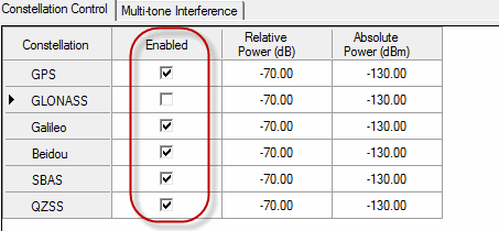
Click Enabled check box to enable or disable satellites of each constellation in currently playing scenario.
EXG/MXG:
[:SOURce]:RADio:GNSS[:BBG]:GPS:ENABle 1|0|ON|OFF
[:SOURce]:RADio:GNSS[:BBG]:GPS:ENABle?
[:SOURce]:RADio:GNSS[:BBG]:GLONass:ENABle 1|0|ON|OFF
[:SOURce]:RADio:GNSS[:BBG]:GLONass:ENABle?
[:SOURce]:RADio:GNSS[:BBG]:GALileo:ENABle on|off
[:SOURce]:RADio:GNSS[:BBG]:GALileo:ENABle?
[:SOURce]:RADio:GNSS[:BBG]:BDS:ENABle on|off
[:SOURce]:RADio:GNSS[:BBG]:BDS:ENABle?
[:SOURce]:RADio:GNSS[:BBG]:SBAS:ENABle on | off
[:SOURce]:RADio:GNSS[:BBG]:SBAS:ENABle?
[:SOURce]:RADio:GNSS[:BBG]:QZSS:ENABle on | off
[:SOURce]:RADio:GNSS[:BBG]:QZSS:ENABle?
Range: -60 dB to 0 dB
Default: 0 dB
Enter a power offset of the selected constellation.
| For Equal Power mode | The Relative Power value is relative to Satellite Power Reference |
| For Range Based mode | The Relative Power value is relative to the original power level in the scenario. |
The above will be applied to all satellite signals belonging to that constellation.
EXG/MXG:
[:SOURce]:RADio:GNSS[:BBG]:GPS:RPOWer <power>
[:SOURce]:RADio:GNSS[:BBG]:GPS:RPOWer?
[:SOURce]:RADio:GNSS[:BBG]:GLONass:RPOWer <power>
[:SOURce]:RADio:GNSS[:BBG]:GLONass:RPOWer?
[:SOURce]:RADio:GNSS[:BBG]:GALileo:RPOWer <power>
[:SOURce]:RADio:GNSS[:BBG]:GALileo:RPOWer?
[:SOURce]:RADio:GNSS[:BBG]:BDS:RPOWer <power>
[:SOURce]:RADio:GNSS[:BBG]:BDS:RPOWer?
[:SOURce]:RADio:GNSS[:BBG]:SBAS:RPOWer <power>
[:SOURce]:RADio:GNSS[:BBG]:SBAS:RPOWer?
[:SOURce]:RADio:GNSS[:BBG]:QZSS:RPOWer <power>
[:SOURce]:RADio:GNSS[:BBG]:QZSS:RPOWer?
Range: -160dBm to 0dBm
Default: -130dBm
Enter the absolute power level of the selected constellation in dBm. This will be applied to all satellite signals belonging to that constellation. Dynamic range of this power level should be within [-60dB - 0dB] range of Satellite Power Reference.
[:SOURce]:RADio:GNSS[:BBG]:GLONass:APOWer <power>
[:SOURce]:RADio:GNSS[:BBG]:GLONass:APOWer?
[:SOURce]:RADio:GNSS[:BBG]:GPS:APOWer <power>
[:SOURce]:RADio:GNSS[:BBG]:GPS:APOWer?
[:SOURce]:RADio:GNSS[:BBG]:GALileo:APOWer <power>
[:SOURce]:RADio:GNSS[:BBG]:GALileo:APOWer?
[:SOURce]:RADio:GNSS[:BBG]:BDS:APOWer <power>
[:SOURce]:RADio:GNSS[:BBG]:BDS:APOWer?
[:SOURce]:RADio:GNSS[:BBG]:SBAS:APOWer <power>
[:SOURce]:RADio:GNSS[:BBG]:SBAS:APOWer?
[:SOURce]:RADio:GNSS[:BBG]:QZSS:APOWer <power>
[:SOURce]:RADio:GNSS[:BBG]:QZSS:APOWer?
Choices: On | Off
Default: Off
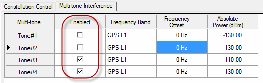
Click Enabled check box to enable or disable an interference tone.
[:SOURce]:RADio:GNSS[:BBG]:MTONe[n]:ENABle <on| off>
[:SOURce]:RADio:GNSS[:BBG]:MTONe[n]:ENABle?
Choices: GPS L1 | GLONASS L1 | Beidou B1
Default: GPS L1
Select the frequency band where the interference tone is located.
[:SOURce]:RADio:GNSS[:BBG]:MTONe[n]:BAND GPS | GLONass | BDS
[:SOURce]:RADio:GNSS[:BBG]:MTONe[n]:BAND?
Range: -8MHz to 8MHz for GPS L1, -4.5MHz - 4.5MHz for GLONASS L1, -4MHz - 4MHz for Beidou B1
Default: 0Hz
Enter the frequency offset of the interference tone, relative to the center of the frequency band - GPS L1 at 1.57542GHz, GLONASS L1 at 1.602GHz and Beidou B1 at 1.561098GHz.
[:SOURce]:RADio:GNSS[:BBG]:MTONe[n]:FREQ <frequency offset>
[:SOURce]:RADio:GNSS[:BBG]:MTONe[n]:FREQ?
Range: -160dBm - 0dBm
Default: -130dBm
Enter the absolute power level of the interference tone in dBm. Set the power level within [-60dB - 0dB] range of Satellite Power Reference.
[:SOURce]:RADio:GNSS[:BBG]:MTONe[n]:APOWer <power>
[:SOURce]:RADio:GNSS[:BBG]:MTONe[n]:APOWer?